Floodplain hydrology and hydraulics
This short report shows some results of the floodplain monitoring in the Dong Thap province of the Mekong Delta. Figure 1 compares water level time series for two stations, representative for main river (T1) and secondary channel in floodplains (H11), respectively, for the years 2008 and 2009. It can be seen that the hydrograph characteristics in the channels and the floodplains are generally identical, except of the tidal influence. The tidal influence is dampened in the floodplains due to lower inundation depths and the low momentum of the huge inundation area in the floodplains.

Fig. 1: Water elevations at station T1 (2008, 2009) and H11 (2009). The coloured boxes in the lower panel indicate the stage of the flood: 1) blue = rising, 2) green= high and 3) red= falling.
The inter-annual comparison shows that in 2008 the first flood peak is more pronounced and the typhoon season increases the flood magnitude only slightly. In 2009, in contrast, there is a more distinct flood peak at the end of October indicating a more violent typhoon activity.
In order to discuss the channel and floodplain inundation dynamics in a more structured way, we divided the typical flood hydrograph in the Mekong Delta in three distinct periods: a “rising stage”, a “high stage”, and a “falling stage”.
“Rising stage”: In this stage the flood regime is controlled by the inflow into the Tonle Sap and the tidal influence. Flood control in the Vietnamese part of the Delta is mainly for crop protection.
“High stage”: With rising water levels the hydrodynamics changes. Floodplain inundation is initiated by overland flow or sluice gate operation in case of closed dike rings and the influence of the tides on the inundation process are diminishing. At the upstream boundary the flow into Tonle Sap is reversing back into the Mekong, while in the Plain of Reeds in the Delta the flood peaks from the Mekong and the overland flow from the Cambodian border coincide.
Falling stage”: From mid-October the water levels generally fall and no further flood peaks caused by tropical typhoons occur. This stage is characterized by rising influence of the tides and widespread human activities to regulate the remaining inundation waters in the floodplains. Traditionally, the waters are pumped from the floodplains when the water level in the channels falls below the elevation of the low dikes. A particular feature at the beginning of this stage, i.e. between mid-October and mid-November, are stagnant and even reversal flow conditions, mainly in east-west leading channels. This feature is visible in the stage-discharge plot given in Figure 2 (red marked data).
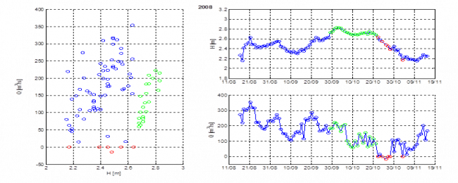
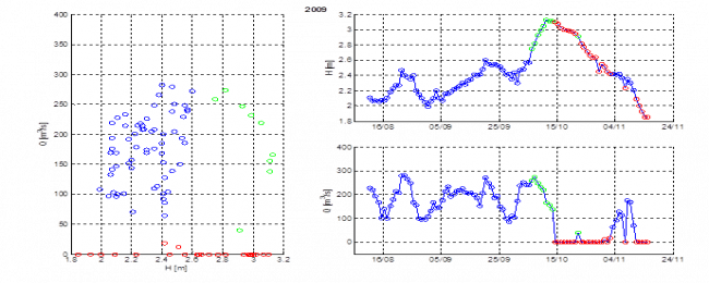
Fig. 2: Stage-discharge relationships at station G1 (cf. Fig. 3) for flood season 2008 and 2009.
In Figure 2, the blue marked data represent the “normal” relation during low flow and the rising stage of the flood, which is dominated by the flood wave of the Mekong. The scatter in the data has to be attributed to the tidal influence. The green data indicate the high stage of the flood, where the flood wave of the Mekong and the overland flood from North-East coincide. The red data indicate stagnant of even reverse flow condition in the first phase of the falling flood stage, where the hydraulic head of the Mekong is falling below or equal to the overland flood wave. Slightly rising water levels in the Mekong by minor flood peaks alleviate this situation, which is well observable in 2009.
Using a series of inundation maps derived from TerraSAR-X for the years 2008 and 2009, we could visualize the impact of the dike system and the human control on the floodplain inundation. Figure 3 shows inundation maps for the three flood stages defined above for 2008 and 2009 at comparable dates. In the rising stage shown in Figure 3 (a), it is noticeable that some floodplain compartments are flooded while others are not. Also most of the dike lines, resp. the channels are still visible. This indicates that most of the floodplain inundation was triggered by sluice gate operation.
During the high stage in mid-October shown in Figure 3 (b), a number of the smaller channels and dikes are no longer visible indicating dike overflow and a hydraulic connection between channels and floodplains as well as between individual floodplain compartments.
In the falling stage the human interference starts again by pumping water out of the floodplains, again starting in the closed dike rings. In Figure 3 (c) the compartment around station H6 is already dry and the new cropping period is about to commence. Logically, in compartments with low dikes the pumping does not start before the water levels in the floodplains fall below the dike level.
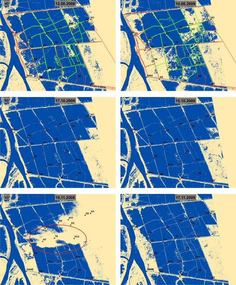
Fig. 3: Inundation maps of the study area derived from TerraSAR-X satellite images during the flood seasons 2008 and 2009 (blue =water, light yellow =no water, green=low dike, red= high dike), a) the “rising” stage, b) the “high” stage, c) in the “falling”. The red circle shows high convective alto-cumulous clouds, which cannot be penetrated by the X-band radar.
Floodplain inundation – temporal dynamics
The particular features of the channel-floodplain interaction identified by the satellite images, i.e. hydraulic linkage and anthropogenic interference, can be quantified in terms of timing and water levels by the ground based monitoring system put into place in the WISDOM project. Figure 4 shows the hydrographs of gauging stations in neighbouring channels and floodplains exemplarily for a dike ring with high dikes (Figure 4a) and a floodplain with low dikes (Figure 4b) for 2009. In case of compartments with high dikes, the floodplain inundation is completely controlled by sluice gate operation. The flood level is generally below the dike levels indicating the flood protection character of the dike ring. The first minor flood peak does not cause inundation in the floodplain due to closed sluice gates. The opening of the sluice gates is recorded by the gauging station H6 within the dike ring. After the opening of the sluice gates, the inundation of the floodplain follows the dynamics of the channel, but with a slight delay. At the end of the flood season the closing of the sluice gates and the operation of the pumps is clearly detectable in the time series by the divergence of the time series in the floodplain and the channel.
In contrast to the dike rings, the inundation of the low dike floodplain compartments is controlled by dike overflow. This is shown in Figure 4b where hydrographs of station H11 in the channel and H3 in the floodplain is shown. Here the onset of the floodplain inundation is clearly related to the lowest dike elevation in the vicinity of station H3: as soon as this level is exceeded, the inundation starts and quickly rises to the level in the channel forming a closed hydraulic connection. The pumping in these compartments cannot start before the water level drops below the dike level. This is also observable in Figure 4b by the divergence of the floodplain and channel water levels below the dike level.
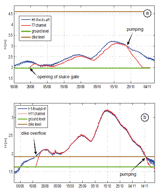
Fig. 4: Comparison of channel and floodplain hydrographs in a dike ring with high flood protection dikes (a) and a floodplain compartment with low dikes (b) for the flood season 2009.
A thorough description of these and more results will be published in Hung et al., “Floodplain hydrology of the Mekong Delta, Vietnam” in Hydrological Processes, which is currently in the review process.


