![]()
![]()

Land Cover Classification II, 2001
The title of this map is “Vietnam – Mekong Delta – Land Cover Classification II, 2001”.
It depicts a classification of the land cover of the earth’s surface derived from satellite data, consisting of natural surfaces, such as vegetation and water, as well as artificial surfaces, such as urban areas. The legend on the right side of the map describes important map attributes, such as the class names, scaling factor, two quicklook images of the data source and additional map information. As the data source of this map, Landsat ETM+ satellite data, acquired of the rainy season from 2001 (©USGS, 2001-12-11) and atmospherically processed prior to map generation, was employed.
Method: The land cover classes were derived from the satellite image using a semi-automated algorithm based on training data from the image. Each class to be obtained from the image is thus represented by a set of training data with similar characteristics, e.g. in this case, spectral information from the satellite image. The algorithm was developed using object-oriented image processing software (Definiens Developer 7). Thereby, the satellite image was split into image objects representing the land cover structures within the Mekong Delta and subsequently classified.
As can be seen in the map, the dominant class in the north-western part of the delta is “Flooded area” (in light blue), in this case predominantly cultivated land which was flooded at the time of satellite image acquisition. The centre of the map comprises mostly “Vegetation, closed”, i.e. more than 60 percent of the surface within this class is densely covered by trees, shrubs or cultivated area (e.g. rice fields or fruit trees), while only a small amount of area is flooded (“Vegetation, flooded” or “Flooded area”). The river and tributaries are distinguishable as “Water, turbid” (dark blue) due to their relatively high sediment load which discharges into the ocean. In contrast, the ocean further offshore is represented by “Water, clear" (very light blue). Ho Chi Minh City in the north-east and urban areas are recognizable in purple.
Additional information included in the map are the borders of the testsites “Tra Cu” district, “Tam Nong” district and ”Can Tho” province of the WISDOM project (displayed in red), the names of their administrative centres as well as other administrative borders such as commune boundaries.
This map was created by DLR for the WISDOM project. For more information please contact Dr. Claudia Kuenzer (claudia.kuenzer@dlr.de), project coordinator on the German side. – June 2008
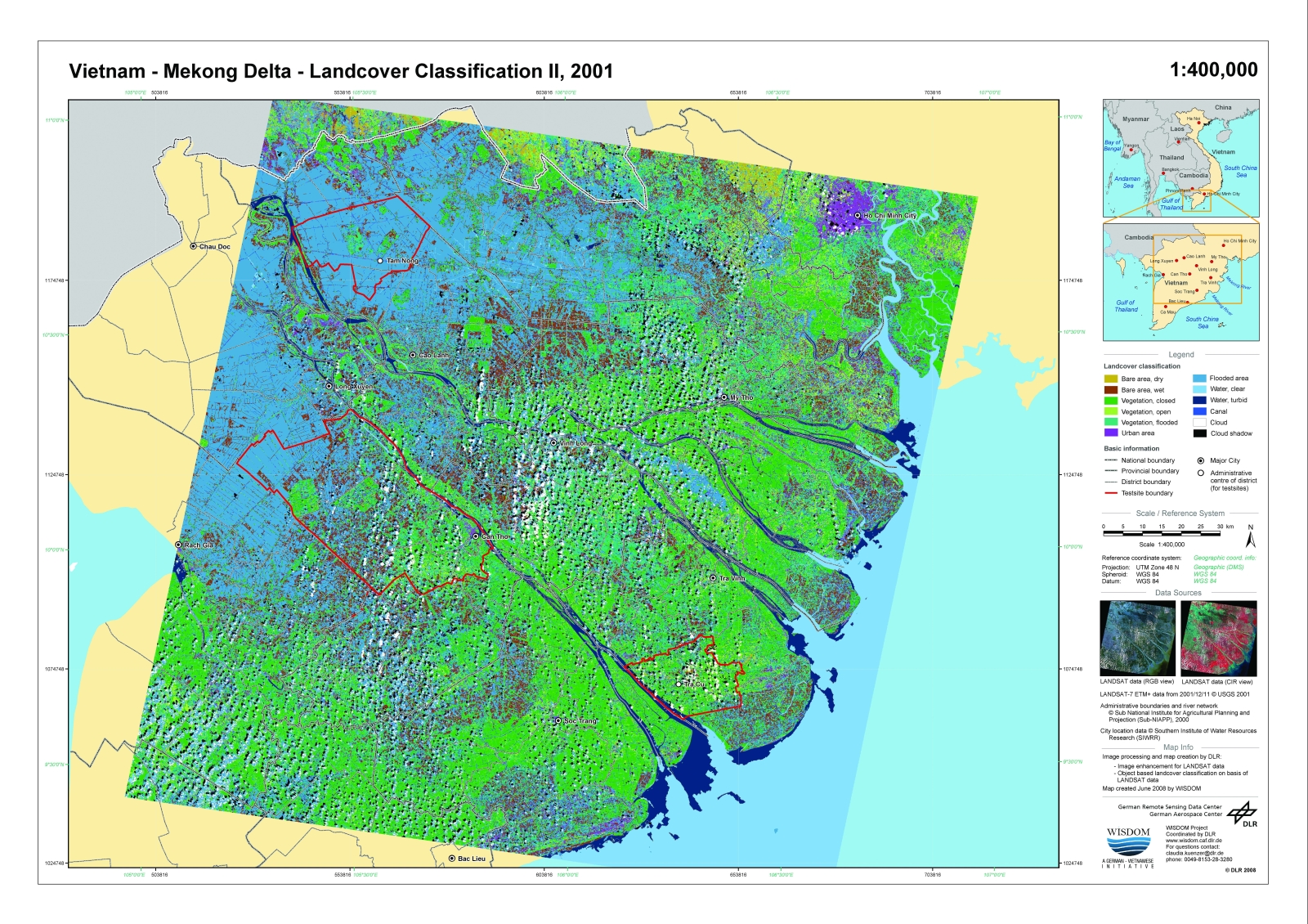
Figure 1 - Land Cover Classification II, 2001