![]()
![]()

Land Cover Classification 2007, from SPOT image – Can Tho Testsite
The title of this map (Fig. 1) is “Land Cover Classification 2007, Can Tho testsite”. It depicts a classification of the land cover of the earth’s surface derived from satellite data, consisting of natural surfaces, such as vegetation and water, as well as artificial surfaces, such as urban areas. The legend on the right side of the map describes important map attributes, such as the class names, scaling factor, two quicklook images of the data source and additional map information. As the data source of this map, SPOT5 satellite data, acquired for the end of the rainy season from 2007 (©Spotimage, 2007-12-23) and atmospherically processed prior to map generation, was employed.
![]()
Figure 1 - Land Cover Classification 2007, Can Tho testsite.
Method: The modular design of the land cover mapping processor consists of an analyses of the significance of the individual features for separability using mostly spectral information extracted from training points (1) the automatic derivation of a decision tree based on the pre-classification of the training points (2) the image classification (3) and finally the validation of the result (4) (Fig. 2).
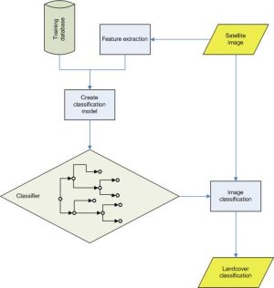
Figure 2 - Workflow of the WISDOM landcover processor.
Preparatory a ground truth database was created, which is filled with manually generated points referring to the spectral information of the classes identified in the satellite image. For the points identified as training samples not only the individual spectral band information is store, but also several additional features such as indices values (NDVI, NDWI, etc.).
First step of the processing chain is a preparatory statistical analysis of the training samples with the data mining software C5.0 (by RuleQuest). The analysis with C5.0 identifies the most probable features for separation of classes, as also specific weight parameters for each feature. Based on these results fuzzy rules are generated, which are then translated to a decision tree automatically. The classification of the satellite image is performed with an implementation of the C5.0 rules in Python language. As post-processing step the spectral classes are combined on the basis of WISDOM classification scheme to land cover classes represented in the map (Fig. 3).
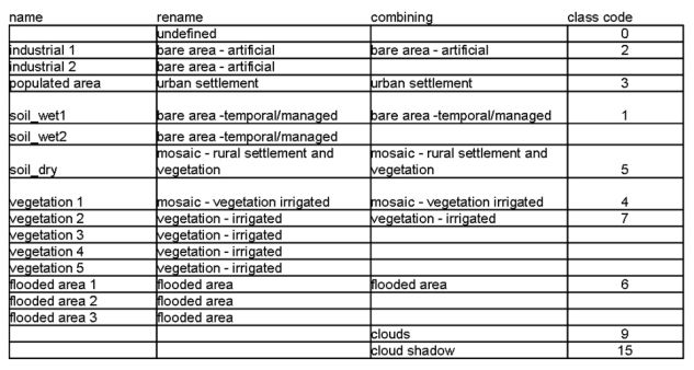
Figure 3 - Recoding and combing classes on the basis of WISDOM classification scheme.
Finally, accuracy assessment is performed with the validation data taken from the ground truth data base (Fig. 4). Further satellite scenes are currently being classified to test the stability of the processor. Ground truth data from the field campaign in January 2009 are incorporated to further improve results.
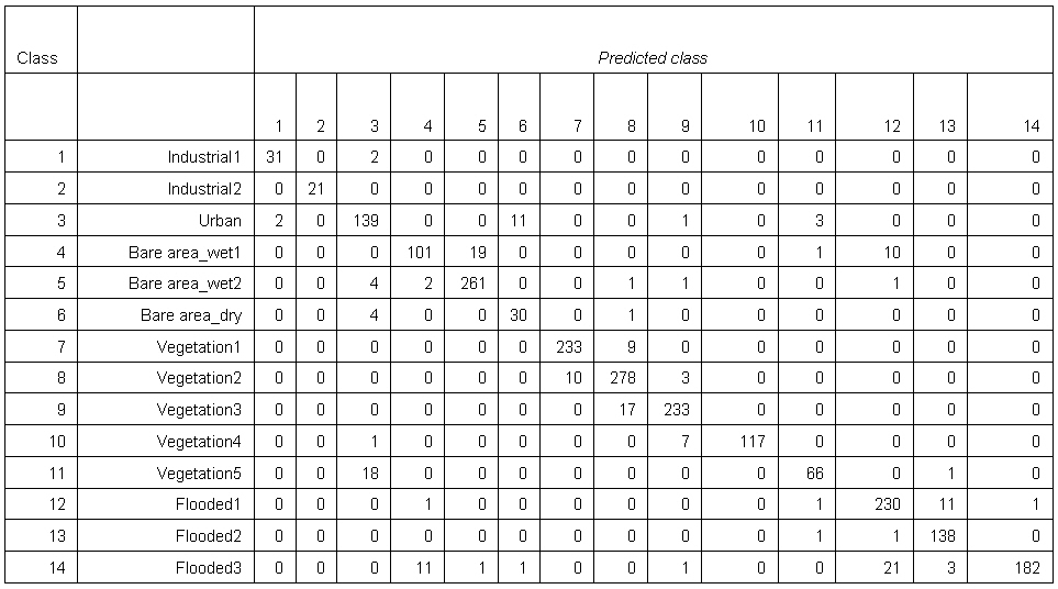
Figure 4 - Accuracy assessment for classification of SPOT 5 – scene from 2007-12-23 as derived by 2060 validation points out of 2234. The overall accuracy is 92.4%.
The classification was produced by DLR for the WISDOM project. For more information please contact Dr. Claudia Kuenzer (claudia.kuenzer@dlr.de), project coordinator on the German side – December 2008.