Spatial variability and uncertainty of floodplain sedimentation monitoring in the Mekong Delta
The floodplain sedimentation samples reported in June 2012 ("Large scale monitoring of floodplain sedimentation") were further evaluated in order to quantify the inherent uncertainty of the sampling procedure and to depict the spatial variability of the floodplain sedimentation. The sample layout of three traps per sampling location enabled an uncertainty analysis of the point samples, which was performed for the first time for sediment samples. The analysis revealed that the sampling uncertainty can be considerably high, and increases with higher deposition masses. Figure 1 illustrates the uncertainty of the different sampling locations in terms of uncertainty bounds.
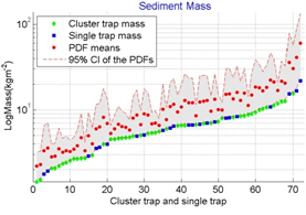
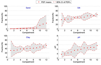
Figure 1: Mean (red dots) and confidence intervals (CI, red dash lines) of sediment mass after wet-dry sampling correction and uncertainty analysis, and original trap data. Sediment masses with indication of cluster and single trap samples.
The nutrient deposition was quantified proportionally to the deposition mass. The uncertainty of the proportions is quite low, thus the uncertainty of the nutrient deposition is directly coupled to the uncertainty of the sediment mass. The spatial distribution of the sedimentation masses was also analyzed. Figure 2 shows the deposition masses for all sampling sites in a map. It can be seen that the deposition masses vary over the Mekong Delta, but a systematic spatial distribution could not be found. This illustrates the high human impact on floodplain inundation and thus sediment deposition in the Vietnamese part of the Delta. Differences in floodplain inundation are thus more distinct between the different dike systems in place, compared to geographic location. Figure 3 shows exemplarily deposition patterns for a low and a high dike compartment. I can be seen that in this case the high dike compartment shows higher deposition masses, but also a higher spatial variability within the compartment. This is explained by the stagnant water during the inundation causing favorable condition for sedimentation, and the inundation pathway via the sluice gates only causing the more pronounced spatial deposition variability within the compartment. Based on the samples deposition masses mean sediment deposition values are calculated for the whole Mekong Delta, but also for different regions and for different dike systems, as shown in Table 2.
The whole study is published in Hydrology and Earth System Sciences:
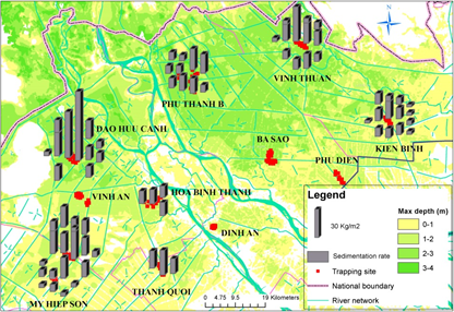
Figure 2: Mean sedimentation rate (grey columns) of all monitoring points.
Table 1: Mean sedimentation values in different spatial units (kg/m2): low dike and high dike, Plain of Reeds/ Long Xuyen Quadrangle and whole VMD.
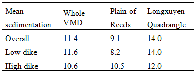
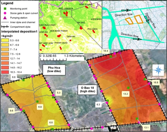
Figure 3: An example of spatial distribution of sedimentation in two nearby compartments in Phu Thanh B.


