Combined fluvial and pluvial flood hazard analysis for Can Tho city
Can Tho city is the largest city and the economic heart of the Mekong Delta, Vietnam. Due to its economic importance and envisaged development goals the city has witnessed a large growth in both population size and extend over the last two decades. Although city development plans exist, the city is growing uncontrolled in many areas, among which some are quite flood prone. In addition also the central parts of the city recently experienced an increasing number of flood events, both of fluvial and pluvial nature. As the economic power and asset values are constantly increasing, this poses a considerable risk for the city. The section 5.4 Hydrology of the GFZ thus performed a probabilistic analysis of both fluvial and pluvial flood hazards. This requires in a first step an understanding of the typical flood mechanisms. Fluvial floods are triggered by a coincidence of high water levels during the annual flood period in the Mekong Delta with high tidal levels, which cause in combination short term inundations in Can Tho. Pluvial floods are triggered by typical tropical convective rain storms during the monsoon season. The increasing sealed surface in the city and the malfunctioning sewer system exacerbate the problem. These two flood pathways are essentially independent in its sources and can thus be treated in the hazard analysis accordingly.
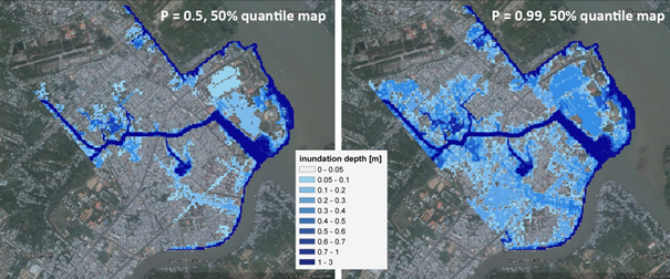
For the fluvial hazard analysis a bivariate frequency analysis of the Mekong flood characteristics, the annual maximum flood discharge Q and the annual flood volume V at the gauging station Kratie was performed. This defines probabilities of exceedance of different Q-V pairs, which are transferred into synthetic flood hydrographs in a Monte-Carlo framework. The synthetic hydrographs are routed through a quasi-2D hydrodynamic model of the entire Mekong Delta in order to provide boundary conditions for a detailed hazard mapping of Can Tho. This downscaling step is necessary, because the huge complexity of the river and channel network does not allow for a proper definition of boundary conditions for Can Tho city by gauge data alone. In addition the available gauge data around Can Tho are too short for a meaningful frequency analysis. The detailed hazard mapping is performed by a 2D hydrodynamic model for Can Tho city. As the scenarios are derived in a Monte-Carlo framework, the final flood hazard maps are probabilistic, i.e. show the median flood hazard along with uncertainty estimates for each defined level of probabilities of exceedance. As an example the median fluvial hazard maps for for probabilities of non-exceedance of 0.5 and 0.99 are shown in Figure 1 below.

Figure 1: Fluvial flood hazard maps Can Tho (Ninh Khieu district) for different probabilities of non-exceedance P
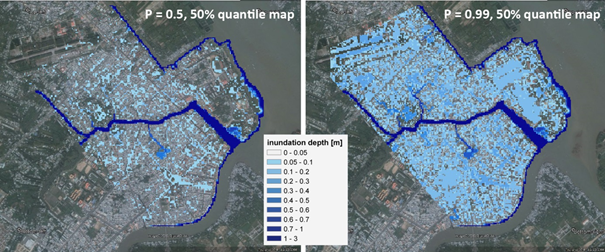
For the pluvial flood hazard a frequency analysis of the hourly rain gauge data of Can Tho is performed implementing a peak-over-threshold procedure. Based on this frequency analysis synthetic rains storms are generated in a Monte-Carlo framework for the same probabilities of exceedance as in the fluvial flood hazard analysis. Probabilistic flood hazard maps were then generated with the same 2D hydrodynamic model for the city. Figure 2 below shows the median flood hazard maps for probabilities of non-exceedance of 0.5 (equivalent to 2 year return period) and 0.99 (equivalent to 100 year return period) exemplarily. According to the assumed random nature of tropical convective rainfall location, the pluvial flood hazard covers the whole study area. The main inundation occurs along topographical depressions and along the roads, similarly to the observed pluvial inundation events in the recent past.

Figure 2: Pluvial flood hazard maps Can Tho (Ninh Khieu district) for different probabilities of non-exceedance P
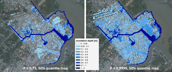
In a last step the fluvial and pluvial scenarios are combined assuming independence of the events, i.e. the probability of the joint exceedance is the product of the individual probabilities of exceedances. These scenarios were also transferred into hazard maps by the 2D hydrodynamic model finally yielding combined fluvial-pluvial probabilistic flood hazard maps for Can Tho. Figure 3 shows the median hazard maps for the lowest and highest quantiles considered. It can be seen that the high spatial coverage of the pluvial hazard is aggravated by the deeper inundation depth caused by the fluvial hazard in the proximity of the water courses.

Figure 3: Joint fluvial and pluvial flood hazard maps Can Tho (Ninh Khieu district) for different probabilities of non-exceedance P
The derived set of maps can provide a basis for an improved city planning, and will be used for a flood risk analysis within the last steps of WISDOM.
Author: Heiko Apel, Oriol Martinez, Do Thi Chinh, Dung-Viet Nguyen (GFZ German Research Center for Geosciences, Section Hydrology)


