![]()
![]()

First Results of the Vulnerability Assessment
First Results of the Vulnerability Assessment (WP 5200)
First field work in the Mekong Delta provided substantial insights into vulnerability patterns and coping strategies with respect to water-related hazards, particularly floods and salt-water intrusion. Through the comparison of these patterns in different communes (within various districts of the pre-defined research provinces) an expedient composition of research sites could be selected. The choice was supplemented by the analysis of socio-economic data that have been collected during the field work.
For Tam Nong district (in Dong Thap province) the analysis showed, for example, that land title has a strong influence on vulnerability patterns. Statistical data revealed that 32% of the rural households are landless (compared to 20% in the entire Mekong Delta). Through interviews with local farmers and authorities it could be deduced that this circumstance is to big parts caused by the failure to build up sustainable livelihood patterns subsequent to the reclamation policy. As a result, high dependencies from off-farm activities can be observed in Tam Nong. Moreover, income opportunities related to fishing (as previously one of the most popular off-farm activities in Tam Nong) are increasingly getting under pressure due to the decline in natural fish stock and the prohibited access to Tram Chim national park. The field work also showed that residential clusters in flood protected areas (dyke system) might cause certain problems due to poor infrastructure particularly with respect to clean water, latrines and sanitation. Moreover, livelihood patterns are likely to be altered which affects vulnerabilities and coping capacities. These aspects will be examined in-depth in the next month.
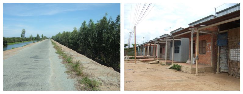
Figure 1: Dyke system and new residential cluster in Tam Nong. Source: own pictures Tuan Vo Van.
In Tra Vinh the main water related problems that have been discovered so far are associated with scarcity of available freshwater. The problems observed can be categorized into the subgroups of salt water intrusion, tidal effects and decrease of groundwater tables. As one of the most important results, these scarcities contribute to the widening of socio-economic disparities between farmers who can afford technical solutions (e.g. pumps or water cleaning facilities) and less wealthy farmers who cannot pay for those equipments. Particularly the spreading of shrimp farming with a high demand for clean(ed) water reveals these dynamics.
Official and technical responses to salt water intrusion in the form of sluice gates proved, in our preliminary analysis, to be highly ambivalent. On the one hand they protect fresh water resources and are therefore very welcome by the population. On the other hand, water levels in the canals were reported to be lowered which results in decreasing run-off and increasing pollution of the canals.
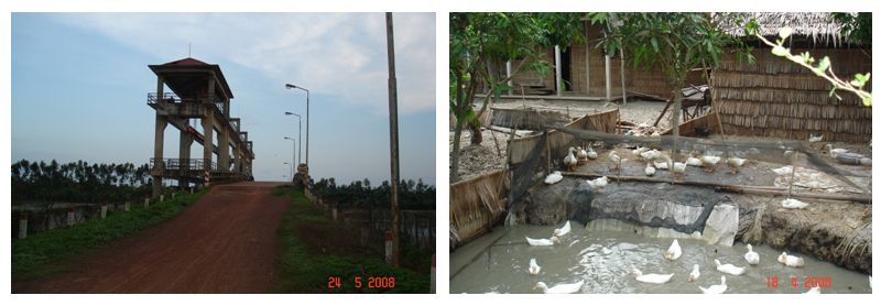
Figure 2: Sluice gate and combined usage of water resources in Cau Ke. Source: own pictures Francesca Burchi.
Based on the explorative field work, in-depth vulnerability assessments will be conducted in Phu Hiep and Phu Thanh B which constitute representative communes of Tam Nong district (Dong Thap province). In Tra Vinh province the communes of Phong Thanh and Phong Phu in Cau Ke district have been chosen as case study sites. In Can Tho the vulnerability assessment will focus on a selection of three to four urban sites.
Future research in these communes will include in-depth interviews and Participatory Rural Appraisal (PRA) with farmers, commune leaders and other local authorities. Out of these, vulnerability indicators will be developed and tested with a questionnaire based household survey in the selected communes. Based on the findings, the vulnerability indicators will then be calibrated.